Point Cloud Rate: Single Return Max – 240,000 pts/s. Multiple returns, max 1,200,000 pts/s.
Scanning Modes: L2 has non-repetitive scanning pattern and repetitive scanning pattern. This increases the likelihood of objects and other details being detected within the FOV. 5 Returns: Up to 5 returns @ 240kHz.
More Concentrated Energy: Smaller beam size – laser spot size is 4 x 12cm @ 100m, 1/5th of the L1.
Efficient: Collect data while flying at up to 15m/s. Cover up to 2.5km-squared in a single flight.
LiDAR Module: Ranging Accuracy: 2cm @ 150m, compared to 3cm @ 100m on the L1.
Laser Ranging: Supported up to 450m.
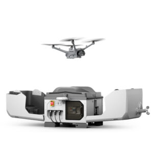
Compatibility: Deploy the L2 with the DJI M400, DJI M350 RTK, and DJI M300 RTK (with DJI RC Plus).
L2 LiDAR Module
Dense Point Cloud Generation
Precision LiDAR Detection: The L2’s LiDAR module detects smaller objects with greater detail and offers enhanced vegetation penetration, resulting in more accurate digital elevation models (DEMs) even in densely vegetated areas.
Increased Detection Range: 450m @ 50% reflectivity, 0klx; 250m @ 10% reflectivity, 100klx. The typical operational altitude extends up to 120 meters.
Point Cloud Rate: Single Return, max 240,000 pts/s. Multiple returns, max 1,200,000 pts/s.
Scanning Modes: Non-repetitive and repetitive scanning patterns increase the likelihood of objects and other details being detected within the FOV.
5 Returns: Up to 5 returns @ 240kHz.
Smaller Beam Size: L2’s laser spot size is 4 x 12cm @ 100m, 1/5th of the L1. This creates denser point clouds.
Ranging Accuracy: 2cm @ 150m, compared to 3cm @ 100m on the L1.
Laser Ranging: Supported, up to 450m.
Enhanced Photogrammetry with True-Colour Imaging
True-Colour Point Clouds
High-Precision Photogrammetry: The L2’s RGB camera enhances photogrammetry missions by creating real-time true-colour point clouds with detailed and accurate visual data.
Key Features of the RGB Camera Include:
4/3 CMOS sensor for high-quality imaging.
20MP resolution for detailed captures.
84° FOV for wide-area coverage.
Mechanical shutter to eliminate rolling shutter blur.
High-speed burst mode with 0.7s intervals.
4K @ 30fps video recording for crisp and clear footage.
High Precision Payload
High-Accuracy IMU
High-Accuracy Positioning: The L2 combines GNSS with a self-developed high-accuracy IMU system to achieve 4cm vertical and 5cm horizontal accuracy, crucial for precise LiDAR data collection.
Instant Readiness: The IMU on the L2 requires no warm-up, enabling immediate operation after start-up, enhancing efficiency in the field.
Precision Metrics Include:
Yaw Accuracy: 0.2° in real-time, 0.05° post-processing.
Pitch/Roll Accuracy: 0.05° in real-time, 0.025° post-processing.
One-Click 3D Point Cloud Generation: Quickly create standard-format 3D point cloud models with a single click using DJI Terra, streamlining the data processing workflow.
Advanced LiDAR Reconstruction: DJI Terra supports DEM creation, ground classification, and automatic GCP generation for precise LiDAR point cloud reconstruction.
Integrated DJI Terra Licence: The L2 includes a DJI Terra licence for processing point cloud data, with easy data export to third-party software like DJI Terrasolid for further analysis.
Flexible Export Formats: Export point cloud models in multiple formats, including PNTS, LAS, PLY, PCD, and S3MB, ensuring compatibility with a wide range of software tools.
Enhanced Operational Experience
Versatile Data Collection
Diverse Flight Routes: Supports Waypoint, Area, and Linear routes.
Point Cloud LiveView: Supports three display modes – RGB, point cloud, and point cloud/RGB side-by-side display. Preview the recorded 3D point cloud model for real-time monitoring.
Point Cloud Model Playback and Merging: After the operation, the 3D point cloud model can be viewed directly in the album.
Auto-Generated Task Quality Report: Following data collection, DJI Pilot 2 app automatically generates a Task Quality Report for real-time, on-site analysis.
PPK Solution: Import original files into DJI Terra to use the PPK process to rebuild high-precision models.
L2 vs L1
Sigificant Upgrades, Increased Efficiency
More Efficient Payload: L2 doesn’t require a 5-10 minute period for IMU warm up. This is required with the L1.
Faster Data Collection: L2 can capture data at 15 m/s flight speed. Recommended flight speed for L1 is 8-13 m/s.
Improved Return Pulse: L2’s maximum return pulse is Penta; L1 has a maximum of Triple return.
Higher Sampling Rates: L2’s pulse rate is 240 kHz with 5 returns; L1 achieves 160kHz with Triple-echo mode.
Denser Point Clouds: L2’s point cloud density is more than 3 times that of the L1, and its detection range has increased by 30%.
Upgraded RGB Sensor: L2 has a 4/3 CMOS sensor and 0.7s shooting interval, compared to L1’s 1-inch sensor and 2 second (minimum) shooting interval.
Reviews
There are no reviews yet.
Be the first to review “DJI Zenmuse L2” Cancel reply


Reviews
There are no reviews yet.